


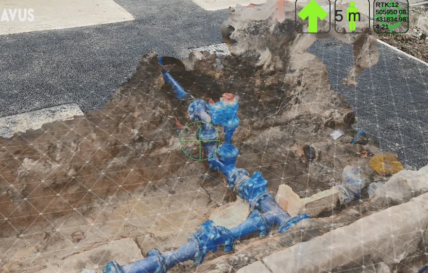
Morrison Utility Services is trialling a new system that uses 2D and 3D augmented reality (AR) to view and map underground services prior to excavation.
Morrison has partnered with Vinci subsidiary Eurovia UK for the supply of its AR technology, Avus (short for Augmented Visualisation of Underground Services), which offers pipe location identification to within 5cm and as-built video capture of geospatial information prior to reinstatement of an excavation. The resulting footage is used to create detailed 3D point cloud models that ensure accurate visual records and ‘x-ray vision’ of the work completed, utility layout and geology for future works.
Morrison is testing Avus, which can be accessed on mobile and tablet, on its Thames Water and Yorkshire Water contracts. The move follows an initial successful trial conducted by a Morrison team working on a bypass and pressure relief valve installation in Roehampton, south London in October 2020.
Andy Carter, director of IT, innovation and improvement at Morrison, said: “Areas in which we are always looking to innovate are born from real-life business challenges. AR is paving the way for many operational processes in our sector to become safer and simpler, and the benefits presented by Avus mean that this technology is a real industry game-changer.
“Using emerging and innovating technologies such as Avus ensures safer working practices and minimises the risk of service strikes by enabling our engineers and operatives to view buried networks virtually via smartphone devices. As well as this, the geo-positioning precision offered by the technology means that the essential infrastructure works that we undertake can be delivered more quickly and more efficiently to keep disruption to the public to a minimum.”
Eurovia UK director of innovation Yogesh Patel added: “When we developed the Avus technology, we always knew that it would make a big impact on the safety and success of planning and programming of works. We are excited to see the benefits of AR applied to the utilities sector – we all have a collective responsibility to manage our infrastructure safely and sustainably. AVUS is a step in the right direction towards this vision.”


