Barking & Dagenham has become the first council to license Vucity, a three-dimensional interactive planning tool that maps more than 100 sq km of central London in high detail.
The borough has purchased a one-year license to the software, developed by communications agency Wagstaffs Design and 3D modeling specialist Vertex Modelling, which enables users to visualise construction development, highlight and interrogate existing, planned and consented schemes, and overlay data, such as sunlight paths, viewing corridors or real-time transport updates.
This is not a paywall. Registration allows us to enhance your experience across Construction Management and ensure we deliver you quality editorial content.
Registering also means you can manage your own CPDs, comments, newsletter sign-ups and privacy settings.
The map will be accessible via a tabletop screen installed in the town hall, enabling residents to view planning proposals and development in the local context, and on iPads installed with the Vucity app.
Darren Rodwell, leader of Barking & Dagenham Council, commented: “This is the future, physical models of London are good but they don’t tell the whole story. Vucity enables us to give developers a better understanding of how we want to do business and the opportunities available in our borough, it is also cheaper for them to buy into the technology rather than have to fabricate models and mock up different views etc.”
He added: “It gives members of the council and local residents an understanding of how the whole borough is developing and helps us get the buy-in we need from the community and investors to facilitate the borough’s future direction.”
Vucity first launched at MIPIM last year and has now been expanded to cover 115 sq km of London to +/-15cm accuracy, including five central London boroughs and stretching from Hammersmith & Fulham, in the west, to London City Airport in the east, and from King’s Cross, in the north, to Battersea and Nine Elms in the south.
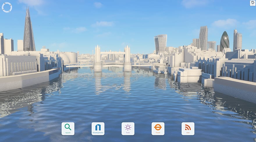
Vucity has been expanded to cover 115 sq km of London to +/-15cm accuracy
The map was recently expanded to include Barking & Dagenham’s two major opportunity areas, the town centre and an area to the north, and features several proposed schemes in the borough. Other licensees include British Land and Capco, which are using the tool during consultation on major schemes.
Jason Hawthorne, managing director of Wagstaffs, said: “The software allows architects, developers, planners and others involved in city planning to upload 3D models of buildings and assess the differences between consented and proposed schemes, daylight studies and Right to Light, things that are only possible using digital technology.
“Most important for us was the high level of model accuracy, which means key London viewing corridors, including protected views to St Paul’s Cathedral and Westminster, are precise and users can immediately see if a building will be affected and how tall it can go.”
He added: “The option to turn on all existing planning consents in the same area means you are suddenly looking at your building against what will be built over the next 15-20 years, providing a much bigger picture of London than was previously possible.”
The 3D map was created using a combination of high resolution aerial photography and photogrammetry. Designs for a number of proposed developments have been input by the Vucity team, which has committed to resurvey the capital and update the map every three years.
“Anything we miss or that has changed from the original planning application, for example through Section 70 of the Town and Country Planning Act, will get picked up and amended. Our model husbandry is as important to us as having created it,” said Hawthorne.
Wagstaffs also plans to offer an online, on-demand version of the service which will be accessible for an hourly rate. “An architect could log in and test a few models and schemes and take some screenshots to understand how a scheme might work. We want to make it as accessible as possible to as many people as possible,” concluded Hawthorne.
This is the future, physical models of London are good but they don’t tell the whole story. Vucity enables us to give developers a better understanding of how we want to do business and the opportunities available in our borough.
– Darren Rodwell, Barking & Dagenham Council